
Hawaii Island, also known as the Big Island, boasts an unparalleled natural beauty that captivates millions of visitors each year. While the sun-kissed beaches and lush rainforests are the highlights for many tourists, there’s another facet of Hawaii’s landscape that intrigues adventurers and scientists alike – its mesmerizing lava zones. These zones, shaped by volcanic activity over millions of years, offer a unique glimpse into the dynamic forces that have sculpted the Hawaiian Islands.
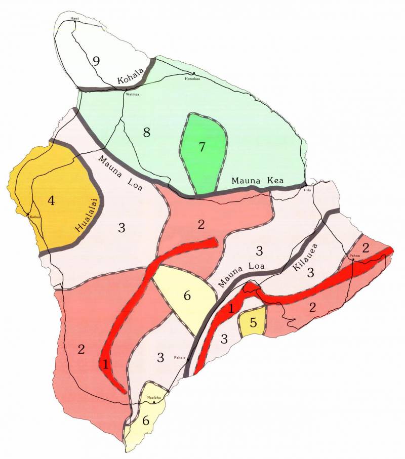
Map courtesy of usgs.gov
Understanding Lava Zones
The Hawaiian Islands owe their existence to a series of volcanic eruptions that occurred millions of years ago. The islands are essentially the visible peaks of massive underwater volcanoes formed by the movement of tectonic plates over a hotspot in the Earth’s mantle. This hotspot, located beneath the Big Island of Hawaii, continues to fuel volcanic activity, making it one of the most geologically active regions on the planet.
To better understand the distribution of volcanic activity and associated hazards, the United States Geological Survey (USGS) has divided the Big Island into various lava zones based on the frequency and intensity of past eruptions. These zones range from Zone 1, which represents the areas at the greatest risk of lava flows and volcanic hazards, to Zone 9, which encompasses the oldest and least active parts of the island.
Exploring the Lava Zones
- Zone 1: Located primarily on the southeastern coast of the Big Island, Zone 1 is the most active and hazardous lava zone. This area has been shaped by frequent eruptions from Kilauea, one of the world’s most active volcanoes. Visitors to this zone can witness firsthand the raw power of volcanic activity, with flowing lava creating new land and reshaping the coastline.
- Zone 2: Moving slightly inland from Zone 1, Zone 2 encompasses areas that have experienced recent volcanic activity but are not currently at immediate risk. Here, visitors can explore lava fields and witness the dramatic contrast between barren, blackened landscapes and pockets of lush vegetation that have begun to reclaim the land.
- Zone 3: As we move further away from the active volcanic vents, Zone 3 offers a more stable environment characterized by older lava flows and established communities. This zone includes towns such as Hilo, Keaau, and Volcano, where residents have learned to coexist with the ever-present threat of volcanic activity.
- Zone 4 and Beyond: Beyond Zone 3, the landscape transitions into older, more stable terrain where the risk of volcanic activity is significantly lower. These zones offer a glimpse into Hawaii’s geological past, with ancient lava flows forming towering sea cliffs and rugged landscapes that showcase the island’s tumultuous history.
- Conclusion
Exploring the lava zones of Hawaii offers a unique opportunity to witness the dynamic forces that continue to shape our planet. From the fiery eruptions of Kilauea to the ancient lava flows that form the foundation of the Hawaiian Islands, each zone tells a story of geological upheaval and resilience. Whether you’re a thrill-seeking adventurer or a curious traveler, a journey into Hawaii’s lava zones is sure to leave you in awe of the natural wonders of the Aloha State.

Leave your opinion here. Please be nice. Your Email address will be kept private, this form is secure and we never spam you.